Out on my ‘less lopsided than normal’ joggle today I was thinking about how many conveniences our digital world has given us – especially as it pertains to global positioning systems(aka GPS). Just think about it, far overhead are dozens upon dozens of satellites whizzing around sending information to receivers on the ground about where in the world you are, where you might want to go, the best route to get there, and (my favorite) how you could get a KrispyKreme along the way. These little receivers are ubiquitously tucked into many of the products we buy today and never given a second thought. So, here is a second thought for you.
Although not an early adopter of the clunky, eye-poking antenna gizmos of last millennium, I proudly embrace the latest advancements in most things tech. Even though at times I am thrust into a personal mini-pity party when it reveals I am running in a particularly sloth-like fashion, I am generally delighted by what information we can avail ourselves of with GPS(and yes for the techie people reading this a nod to GIS that brings it all to life).
However, when one is travelling to remote locations here is what I have come to realise – in that oh no, here we go down the dark alley kind of way – keep your Google Earth, Google Night Sky, Google Maps, Google Directions and all of those wonderful things and just give me an icon I can click on to tell me what the locals call the place. Seriously, if we could ‘drop a pin’ on the place we wish to traverse and up would pop the ‘given name’ of the locale and perhaps some local lore as to how it got its name and maybe a glimpse into those who have traversed the location then we would be much better equipped to schlep across the expanse we have our eyes set on. Let me give you a few examples from my own unwitting explorations.
Last millennium I was encouraged to do a run in California, USA by two wonderful women I worked with in Bermuda. (Hello Angela and Willa-Mae can you believe I am doing another crazy adventure!). And they really did have my best interest in mind when they thought focusing on a run-adventure would help me get through a few personal dilemmas. Of course, a small item which led to early enthusiasm was only reading tab 1 of a 5 tab spread sheet on the elevation gain/loss and distance of the course ☹…details, meh.
Anyhow, I jumped at the thought of the run sort of like when you first walk into a fancy ice cream shop and see all the exotic flavours on the wall. I am always taken by how Pistachio ice cream gets it deep green color, and how the moose tracks look like moose tracks. So, I sprang into training and learning about shoes and blisters and hydration and all the scientific oddities that go with these things. And of course, I knew that the race went from the lowest point in the Western Hemisphere up to one of the highest points, Mt. Whitney – how cool does that sound! And sure it went through Death Valley and such. But it never really sunk in, until there I was, ready to order my ice cream and faced with the reality of the location I was standing in… about to trot 136 miles through place names I really should have researched more thoroughly.
I mean think about it… if something is called D-E-A-T-H- V-A-L-L-E-Y and you will be running through the D-E-V-I-L-S P-L-A-Y-G-R-O-U-N-D shouldn’t one be the least bit concerned or curiosity piqued? Did I mention the race was the last weekend in July aka the height of summer in the Western Hemisphere. Now, think if Google had a little icon over ‘Furnace Creek, CA’ that would tell an inquiring mind that the hottest temp ever recorded in the USA happened right there (134 degrees F). At least put one of those flame emojis there!
And if Google really wanted to complement their stunning ability to synthesize data they could add this little excerpt from Born to Run the moment anyone using Google Directions clicks on the walking option, “…the air is so dry that by the time you feel thirsty, you could be as good as dead; sweat sucked so quickly from your body, you can be dangerously dehydrated before it even registers in your throat… running down the sizzling blacktop of Highway 190, making sure to stay on the white lines so the soles of [your] running shoes don’t melt”. And my favorite, ‘This is the landscape of catastrophe’. I hereby dub this new icon the “Eekon” based on my observations of the verbalization – Eek! as the sound people emit when the local meaning of place names become known or the obvious finally registers.
This concept of an Eekon becomes even more valuable when you slip the borders into foreign lands during flights of fancy. Funnily enough in 2003 I found myself thrilled to be going to the Gobi Desert to saunter across the singing sand dunes and glacial plateaus that sit in outer Mongolia. (squeal, I have always wanted to use the word funnily and see what spell check says…and it is OK!). Of course, it was poor timing to be heading anywhere near China as SARS was is in its peak stage, however, that left 5 seats clear on the long haul flights!
When I finally resurfaced in Dunhuang and met at the hotel for the inaugural Gobi March there was an added banner to the official one (see picture). As the story goes when the locals heard about the race they said something along the lines of ‘oh, they are going into the place of no return….’.
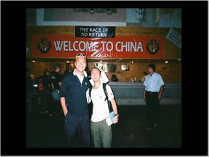
Note the banner in black.
Now, go search for Dunhuang and singing sand dunes… you will get nary a mention of the place of ‘no return’. But, if Google had that Eekon icon you would be all set and perhaps avoid the dizzying days of crossing salt flats and wandering dried river beds – or at least if you chose to still wander the terrain you would be mentally more attune to what lay before you. NB: The race organisers removed the ‘locally-flavored’ banner shortly after it was hung, I suspect due to unrest among the handful of competitors and/or their loved ones.
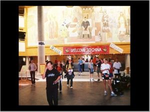
The next morning, voila.
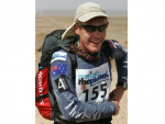
But wait, there is more for my newly initiated Toponomy friends. Go check out the Teklamakan Desert. Yup, nestled at the west end of the Gobi and running out towards the ‘stans. It was here on Race day 3, in Gobi March II, that one of the local folk said ‘Yes today you cross The Oven’. My sand matted brow creased like no ones business when I overheard this. I was too preoccupied with hydration to let flow the tears, so I tucked in for a long day across salt flats which lead me to a long night over giant sand dunes that devoured glow sticks and runners alike. Here is a cool pic of The Oven… and here is a pic of a runner I found sitting cross-legged and mumbling atop one dune.(Hi Matt, still one of the coolest nights of my life! Can you believe I am doing another crazy adventure?)
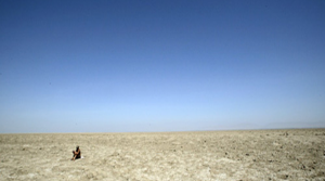
So aptly named The Oven by the locals.
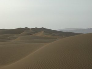
The Dunes in the back of the Oven
And the lovely Matt Chapman with whom I shared a once in a lifetime stroll as we navigated our exit of the Oven
And I could go on, so I will, check it out, what the locals call the ‘Flaming Mountains’ outside of Urumqi, China or the Valley of the Moon in the Atacama Desert, Chile. (Actually, the locals alternate between Valle de Luna and Valle de Muerte… moon or death, just depends if you are a glass half full person or not…). Each a fabulous location and natural wonder in its own right, I just wish I had been more attentive to what the local populaces thought of the notion of crossing these places on foot- or even crossing them at all.
The teachable moment here, for any educators following this blog, is that I have wised up ever-so-slightly over the years and done a bit of research for this ‘Follow the Zebras’ adventure. And guess what, good news! The Serengeti is a vast ecosystem in east-central Africa spanning 12,000 square miles (30,000 square kilometers), according to NASA, giving rise to its name (wait for it!), which is derived from the Maasai language and means “endless plains.” This region of Africa is located in north Tanzania and extends to southwestern Kenya. Not one mention of ovens, or death, or flaming, or moon!
Doesn’t that sound inviting? Wonderful expanses of geological magnificence, golden sunsets with silhouettes of a singular tree alongside a gaggle of giraffes.( FYI a group of giraffes is called a tower, but I enjoy alliteration so much I took a blog liberty). I think this is going to be a geographically smart place to visit. Of course, the wildlife that inhabits these friendly sounding plains is for another blog post all together.
Just to recap what I thought about on the first half mile of my run today… 1) Google needs an Eekon (icon depicting local lore regarding a location); 2) Until Google brings this on-line it is always good to check with locals regarding terrain you will be crossing; 3) From a topographical standpoint I think we are in a good place heading to this land of vast plains; 4) do not let mind wander towards what lies in wait on these endless plains.
BONUS Blog blurb: I would also be terribly remiss in pointing out one of the greatest topographical name switch-a -roos in history if we did not give a nod to the Iceland – Greenland legend. Wherein some crafty Vikings referred to the lush oasis and oft verdant Island as ‘Ice-land’ and then directed everyone to the neighboring land of moonscapes and icebergs as ‘Green-land’. Apparently, every year a few bargain seeking travelers still get caught out with this toponymous trick.